
Land Survey
Delivering Sustainable Development Projects with Precision, Purpose, and Proven Impact on the Ground.
Introduction
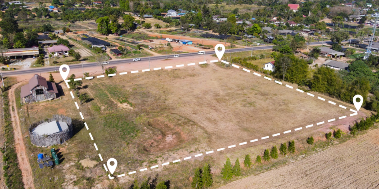
Accurate land records are the foundation of transparent governance, efficient infrastructure planning, and sustainable development. At SR Asia, we specialize in Digital Land Surveying using Differential Global Positioning System (DGPS) and GIS technologies to deliver high-precision, reliable, and verifiable land data for governments, corporates, and community stakeholders.
Our work with the Revenue & Land Settlement Department, Government of Mizoram, has demonstrated our ability to carry out large-scale, scientifically robust land surveys that strengthen land governance, support planning, and safeguard the rights of stakeholders.
What's next for Land Survey?
SR Asia is focused on advancing large-scale DGPS-based surveys, modernizing cadastral records, and integrating legacy land data into digital platforms. We are also expanding our services to support smart cities, renewable energy projects, mining corridors, and community rehabilitation efforts. Our next phase emphasizes transparency, technology-driven governance, and participatory land management for sustainable growth.
Our Drivers
DGPS-Based Land Surveying
We conduct high-precision land surveys using Differential GPS, Total Station, and GIS-enabled mapping. Our services include boundary demarcation for urban expansion, infrastructure projects, mining, industrial corridors, and agricultural planning with centimeter-level accuracy.
Precision Land Surveying for Modern Governance
Accurate land records are the foundation of transparent governance, efficient infrastructure planning, and sustainable development. Our work with the Revenue & Land Settlement Department, Government of Mizoram, demonstrates our ability to carry out large-scale, scientifically robust land surveys that strengthen land governance and safeguard stakeholder rights.
Government Partnership Success
Successfully empanelled with Government of Mizoram – Revenue & Land Settlement Department for high-precision DGPS land surveys across challenging terrains, supporting digitized and transparent land ownership systems.
Comprehensive Land Survey & Mapping Services
End-to-end geospatial solutions from field survey to digital integration
DGPS-Based Land Surveying
High-precision land surveys using Differential GPS, Total Station, and GIS-enabled mapping with centimeter-level accuracy for reliable boundary demarcation.
Geo-referenced Land Parcels
Centimeter-level accuracy with DGPS technology
Boundary Demarcation
Urban expansion, infrastructure, mining, industrial corridors
Agricultural Planning
Precise mapping for agricultural development projects

Cadastral Mapping & Record Modernization
Updating and digitizing cadastral maps to align with state revenue records, supporting government land reforms and dispute resolution.
Legacy Record Integration
Digitizing historical land records with modern systems
Land Reform Support
Government land acquisition and dispute resolution
Revenue Record Alignment
Synchronizing cadastral maps with state revenue systems
Infrastructure & Development Planning
Providing accurate land data for major infrastructure projects including roads, railways, industrial parks, SEZs, and renewable energy developments.
Site Suitability Analysis
Geospatial analysis for optimal site selection
Land Use Classification
Detailed mapping for development planning
Environmental Compliance
Supporting environmental clearance processes


Community & Governance Applications
Supporting governments in land consolidation, resettlement planning, and facilitating participatory land governance through accessible and transparent data.
Land Consolidation
Resettlement and rehabilitation planning support
Resource Management
Community-level mapping for forestry and rural development
Transparent Governance
Making land data accessible to communities
Our Approach & Methodology
Combining technical precision, IT solutions, and international best practices for unmatched land survey services
Technology-Driven Surveys
DGPS, Total Station, drone-enabled photogrammetry, and GIS-based spatial analytics
AI & Data Analytics
Python, AI models, and remote sensing for land classification and predictive mapping
International Standards
FGDC, ISO 19115, NLRMP, and Survey of India norms compliance
Data Quality & Verification
Multi-stage validation with ground-truthing and revenue record integration
Path-Breaking Results
Centimeter-level accuracy reducing disputes and accelerating project clearances
Data-Backed Decisions
Enabling evidence-based decision making for governments and industries
Standards & Compliance Framework
Federal Geographic Data Committee compliance
Geospatial Metadata international standards
National Land Records Modernization Programme
National surveying authority norms
What SR Asia Offers
Comprehensive geospatial solutions from field survey to digital integration
High-Precision Data
DGPS and GIS-enabled mapping with international-grade centimeter-level accuracy for reliable land records.
End-to-End Solutions
Complete workflow from field survey → mapping → cadastral update → GIS integration → digital dashboards.
Technical Expertise
Team trained in surveying, GIS, remote sensing, and data analytics with proven field experience.
Government Partnerships
Experience with Revenue Departments, Smart Cities, Industrial Development Authorities, and Mining Projects.
Scalability
Capability to handle large-scale, multi-district land surveys under challenging terrains and tight timelines with consistent quality and accuracy standards.
Our Competitive Edge
What sets SR Asia apart in the land surveying and geospatial services sector
Proven Government Experience
Successful execution of DGPS land survey with Government of Mizoram, demonstrating capability in challenging terrains and government partnership excellence.
Global Standards, Local Expertise
Compliance with international survey standards (FGDC, ISO 19115) adapted to Indian conditions and regulatory requirements for seamless project execution.
Technology Leadership
Leveraging DGPS, drones, AI, Python-based geospatial analytics, and GIS dashboards for cutting-edge surveying solutions and data accuracy.
Accuracy & Transparency
Delivering centimeter-level precision data that reduces land disputes, strengthens governance, and provides transparent, verifiable land ownership systems.
Integrated Services
Linking land survey outputs with infrastructure planning, environmental assessments, and CSR/ESG projects for comprehensive development solutions.
CONNECT WITH US
Have a question, idea, or opportunity? Let's connect and build something impactful together.