
GIS Task Submission
– Spatial Insights for SR Asia Socio-Economic Survey (BLSES) and Resettlement Action Plan (RAP) – Sasti & Ramnagar Villages, Ballarpur, Maharashtra
Introduction
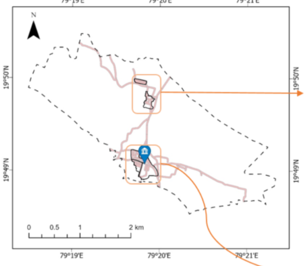
This report presents the Baseline Socio-Economic Survey (BLSES) and Resettlement Action Plan (RAP) for the project-affected region of Sasti village and the adjoining Ramnagar area in Rajura Taluka, Chandrapur District, Maharashtra. Located about 18 km south of Chandrapur, Sasti lies within the Vidarbha region and covers an area of 8.075 sq. km (807 hectares) under its Gram Panchayat. The community is linguistically diverse, with Telugu, Marathi, and Hindi being the commonly spoken languages. Surrounded by coal mining activity, Sasti faces challenges such as displacement, environmental risks, and land-use changes. The Region of Interest Map (Map 1) illustrates the Sasti Gram Panchayat boundaries and provides the foundation for GIS-based analysis and socio-economic assessment in this study.
What's next for CSR Project Management?
The future focus for Sasti and Ramnagar revolves around resettlement planning, considering the risks posed by nearby coal mining activities such as noise, dust, land subsidence, and water contamination. Sustainable land-use management will be vital, with agriculture, forest, and built-up areas requiring balanced development. Monitoring air quality (SO₂ and PM2.5) and studying long-term precipitation trends (1985–2022) will guide environmental safeguards. Improved infrastructure and road connectivity will also play a central role in supporting safe relocation and ensuring the well-being of affected communities.
Our Drivers
Demographics
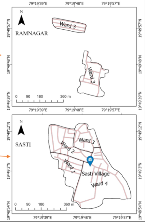
Sasti and Ramnagar together account for around 950 households distributed across four wards, with Ward 4 being the most populated. Understanding the ward-wise settlement distribution is vital for planning relocation and resource allocation, ensuring that vulnerable groups receive adequate support.
Social Responsibility Asia (SR Asia) — GIS Tasks Submission
Project: Baseline Socio-Economic Survey (BLSES) and Resettlement Action Plan (RAP) of the project-affected area i.e. Sasti village (Dhopatala Mine — Ballarpur area), Chandrapur, Maharashtra
Introduction
Project: Baseline Socio-Economic Survey (BLSES) and Resettlement Action Plan (RAP) of the project-affected area i.e. Sasti village coming under Dhopatala (Sasti UG to OC) Mine, of Ballarpur area, Chandrapur, Maharashtra
Region of Interest (ROI): Sasti village and the adjoining Ramnagar area
Sasti is a village located in Rajura Taluka in Chandrapur District of Maharashtra State, India. It belongs to the Vidarbha region and is located 18 KM to the South of the District headquarters Chandrapur. The local language spoken here is Telugu, Marathi, and Hindi (1). The total area under Sasti gram panchayat is 8.075 square km (807.4971 hectares).
Task 1 — Ward mapping, LULC, Mines, Roads, Settlement & Environmental Analysis
Contains Task 1.1 → 1.7 as per PDF▼
Task 1 — Ward mapping, LULC, Mines, Roads, Settlement & Environmental Analysis
Task 1.1
1.1.1 Sasti Village Ward Map
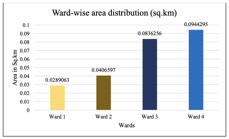
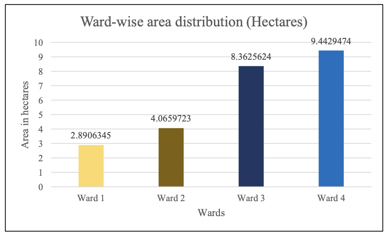
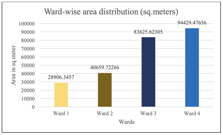
1.1.2 Ward-wise area distribution
Table 1: Ward-wise area distribution as well as total area covered by Sasti gram panchayat.
| Demarcation | Area (Square Kilometers) | Area (Square meters) | Area (Hectares) |
|---|---|---|---|
| Area under Sasti Gram Panchayat | 8.07497025 | 8,074,970 | 807.4970093 |
| Sasti | 0.1893111 | 189,311.0938 | 18.9311085 |
| Ramnagar | 0.05830931 | 58,309.32 | 5.830932 |
| Ward 1 | 0.0289063 | 28,906.3457 | 2.8906345 |
| Ward 2 | 0.0406597 | 40,659.72266 | 4.0659723 |
| Ward 3 | 0.0836256 | 83,625.62305 | 8.3625624 |
| Ward 4 | 0.0944295 | 94,429.47656 | 9.4429474 |
| Project affected area | 0.24762041 | 247,620.4138 | 24.7620405 |
Explanation: The above table talks about the area of different demarcations in Sasti village and its wards... (keeps explanation text exactly as in PDF)
Task 1.2: LULC & Taluka Overview
1.2.1 Land Use and Land Cover Analysis of Rajura and Ballarpur Taluka
Rajura and Ballarpur are two talukas located in the Chandrapur district of Maharashtra (2). Ballarpur is a taluka headquarters and is surrounded by Chandrapur, Rajura, Pombhurna, and Korpana talukas (3). Rajura is a town and municipal council located on the banks of the Wardha River in central India’s coal belt (4).
1.2.2 Location Map of Rajura and Ballarpur Taluka
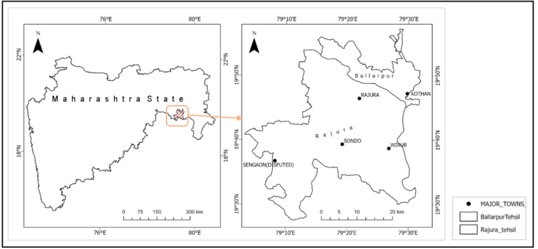
Ballarpur Taluka (2011 Census)
- A subdivision of Chandrapur district in Maharashtra, India. It has 31 villages and 3 towns.
- Population: 134,540 people, with 9.98% children, 50.63% males and 49.37% females. Sex ratio: 937 females per 1000 males.
- Literacy: 75.94% (81.36% males, 70.16% females).
- Area and Density: 260.54 sq.km with 516 people per sq.km. 23.68% urban, 76.32% rural.
Rajura Taluka (2011 Census)
- Demographics: population 138,408 (71,136 males, 67,272 females). Child population (0-6): 14,525 (10.49%).
- Literacy: 70.63% (76.1% males, 64.84% females).
- Area & Density: 894.92 sq.km; density 155 per sq.km.
- Urban/Rural split and SC/ST percentages as in the PDF.
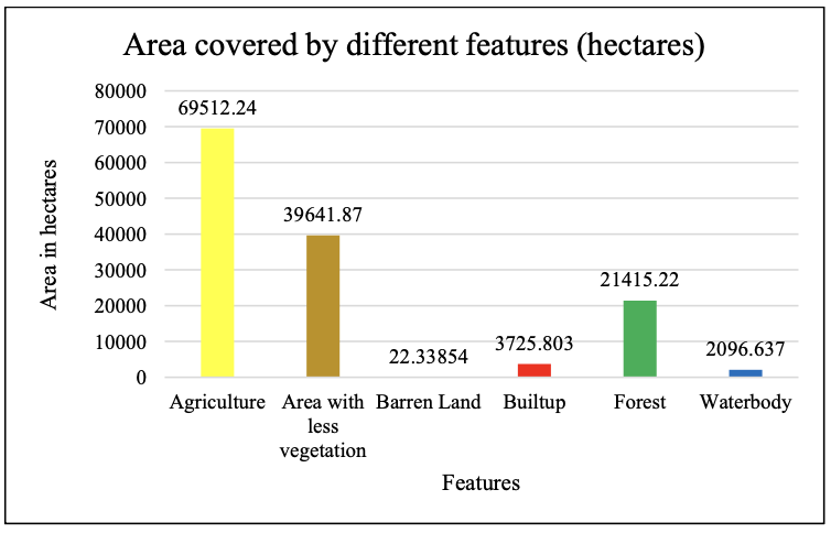
1.2.3 Land Use and Land Cover Map of Rajura and Ballarpur Taluka
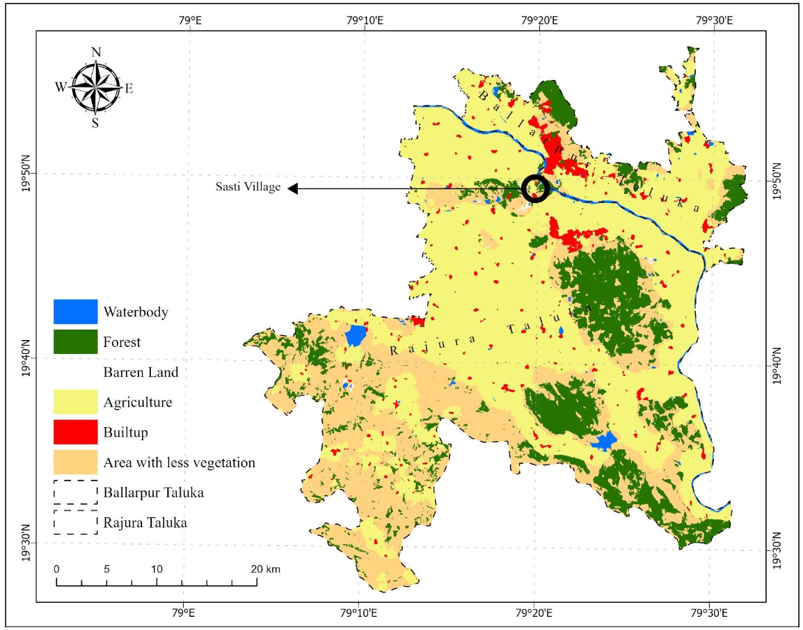
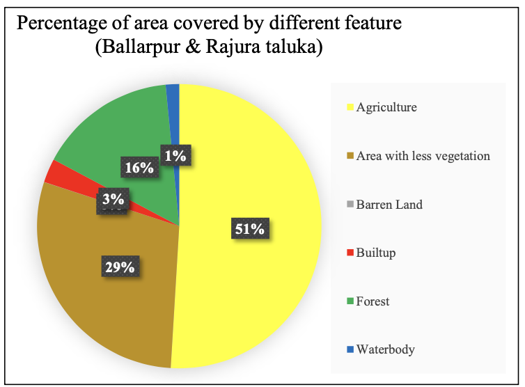
Explanation: The land use and cover data reveal a landscape dominated by agriculture (69,512.24 ha). Areas with reduced vegetation (39,641.87 ha) and barren land (22.34 ha) indicate potential environmental stress. Built-up: 3,725.80 ha; Forest: 21,415.22 ha; Waterbodies: 2,096.64 ha.
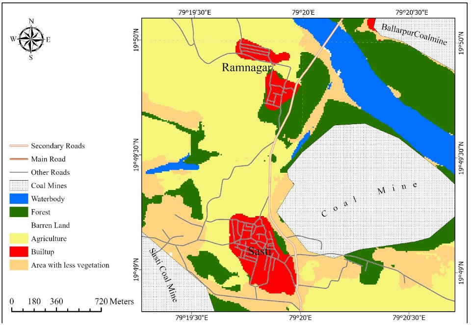
1.2.4 LULC Map of Sasti & Ramnagar
Task 1.3: Coal Mines within 2 Km Radius
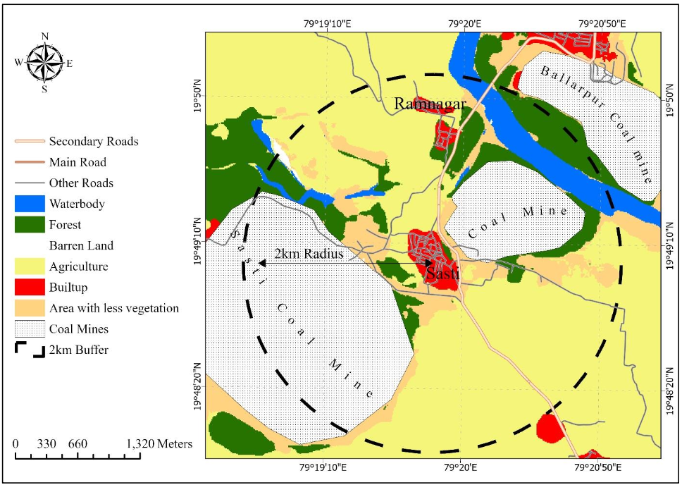
Within the immediate 2-kilometer radius surrounding Sasti village, there exist two coal mines. One of these coal mines, the Ballarpur coal mine, is situated near the outer boundary of the 2-kilometer buffer zone.
The proximity of coal mines within a 2 km radius poses risks: elevated noise levels from dynamite explosions, potential air quality degradation, dust release, ground vibrations, water contamination threats, land subsidence, wildlife displacement, and socio-economic stress for agriculture-dependent livelihoods. Monitoring, mitigation, and community engagement are recommended.
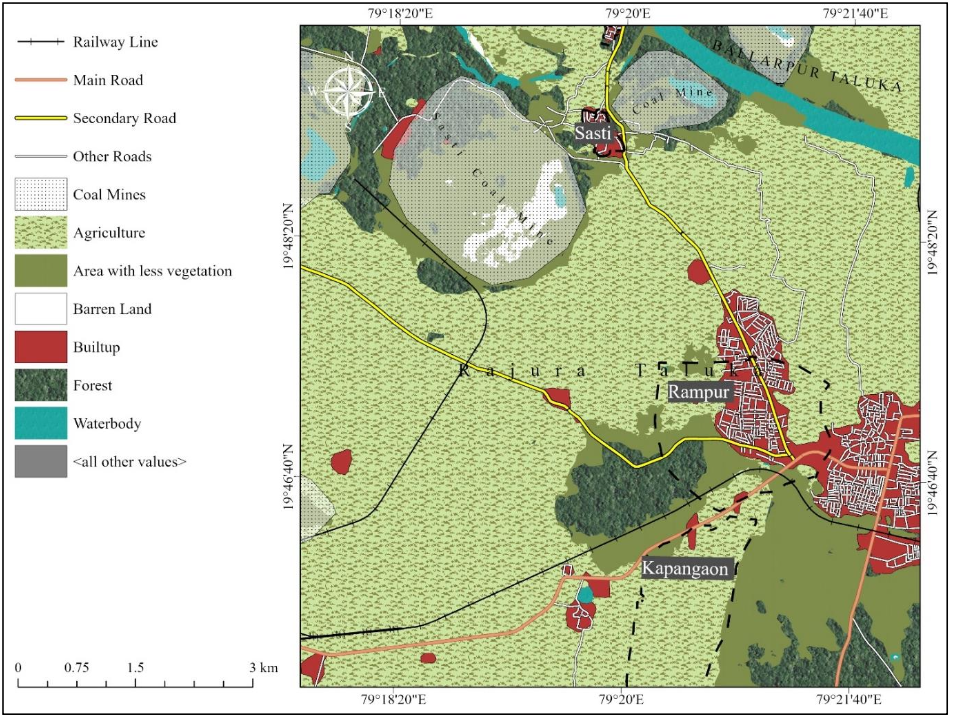
Task 1.4: Inner Roads & Connecting Roads
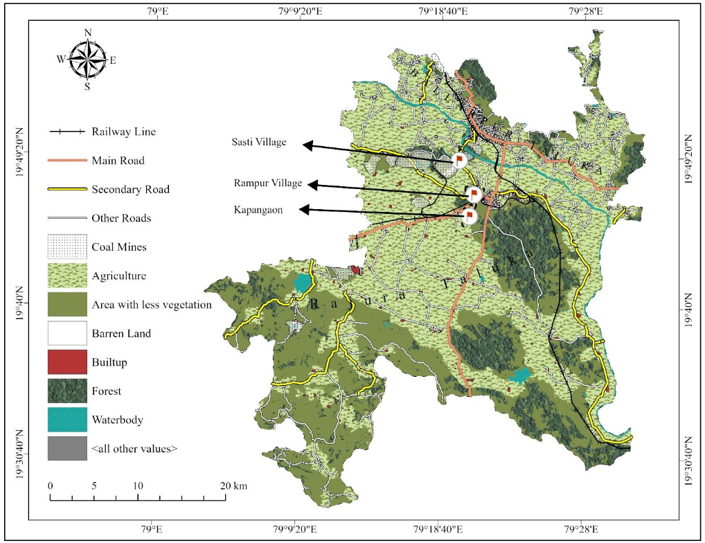
1.4.1 Inner Roads and The Connecting Roads to Sasti, Rampur and Kapangaon
(Map and description included — keep exact text from PDF)
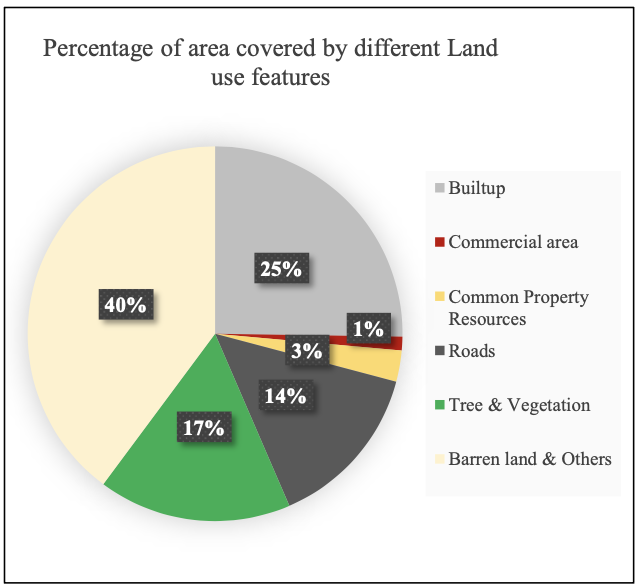
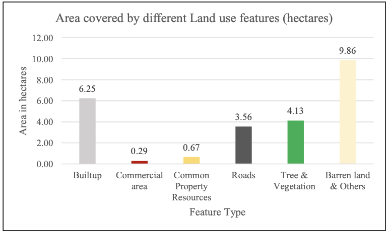
Task 1.5: Land Use & Land Cover Demarcation
The key feature types and their respective areas in hectares are outlined. Built-up area: 6.25 ha; Commercial areas: 0.29 ha; Common property resources: 0.67 ha; Roads: 3.56 ha; Tree & vegetation: 4.13 ha; Barren land & others: 9.86 ha.
1.5.1 Settlement area calculation
Note: Built-up area refers to land covered by buildings; settlement area includes built-up plus other land uses supporting human settlement (parks, open spaces).
Overall village area and other features area (Hectares)
- Total area of Sasti and Ramnagar: 24.7620405 (Overall village area)
- Total CPR area: 0.6669446 8.3560767 (Combined area)
- Total area covered by Roads: 3.5633221
- Trees & Vegetation: 4.12581
Estimated Settlement area of Sasti and Ramnagar — see PDF for exact step-by-step explanation and final figures (Settlement area: 16.4059638 hectares).
1.5.2 Settlement Area Calculation for Each Ward
Formula 1: Proportion of Ward (i) = Ward i Area / Total Village Area.
Formula 2: Settlement Area for Ward (i) = Proportion of Ward i * Total Settlement Area.
Data:
- Total Village Area = 24.7620405 Hectares
- Total Settlement Area = 16.4059638 Hectares
- Ward 1 Area = 2.8906345 Hectares
- Ward 2 Area = 4.0659723 Hectares
- Ward 3 Area = 8.3625624 Hectares
- Ward 4 Area = 9.4429474 Hectares
Calculation Results:
Ward 1 Settlement Area ≈ 1.9139852 hectares
Ward 2 Settlement Area ≈ 2.6929674 hectares
Ward 3 Settlement Area ≈ 5.5402167 hectares
Ward 4 Settlement Area ≈ 6.2567946 hectares
1.5.3 House Count Ward Wise in Sasti & Ramnagar Village
Note: Delineation of house boundaries was executed using ArcGIS Pro digitization. Counts may vary with image resolution.
| Ward | House count |
|---|---|
| Ward 1 | 130 |
| Ward 2 | 271 |
| Ward 3 | 245 |
| Ward 4 | 304 |
| Total House | 950 |
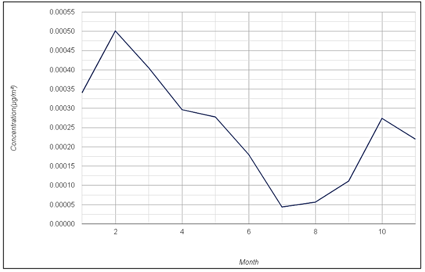
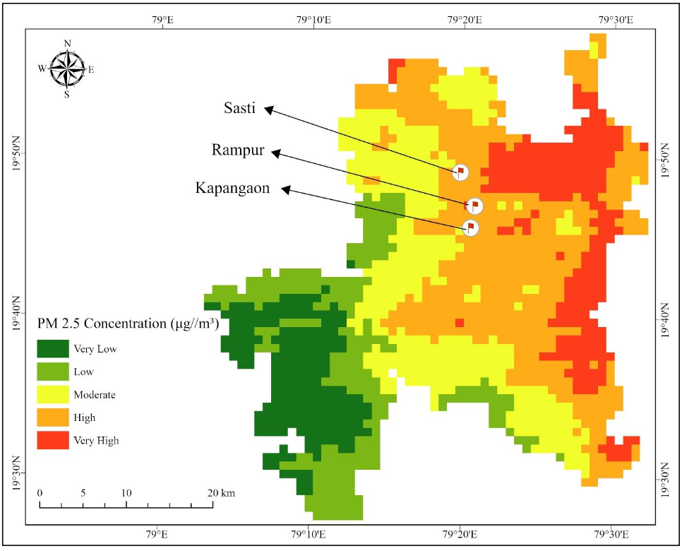
1.6 Air Pollution Mapping (SO₂ & PM2.5)
Sulfur dioxide (SO₂) Concentration Map of Rajura and Ballarpur Taluka | Date: 01-01-2023 to 30-11-2023
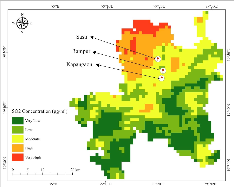
(Sources & references included in References section)
1.7 Precipitation Trend (1985–2022)
Precipitation Trend of Rajura and Ballarpur Taluka | Year: 1985 to 2022
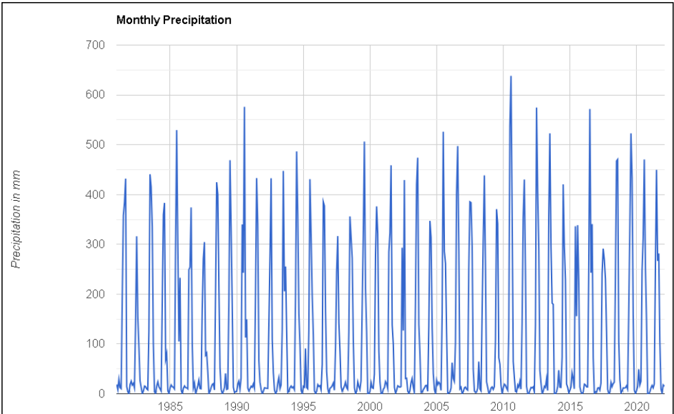
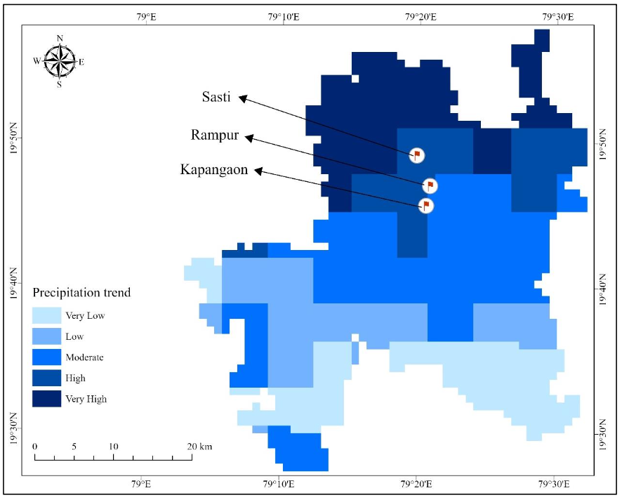
Figure 12: Precipitation trend — 37-year analysis (1985–2022)
References
- Sasti Village, Rajura Taluka, Chandrapur District (onefivenine.com)
- Subdivision & Taluka | District Chandrapur, Government Of Maharashtra | India (chanda.nic.in)
- Ballarpur Taluka | Ballarpur Taluka map (onefivenine.com)
- Rajura - Wikipedia
- Ballarpur Taluka Population Chandrapur, Maharashtra, List of Villages & Towns in Ballarpur Taluka (censusindia2011.com)
- Rajura Taluka Population Chandrapur, Maharashtra, List of Villages & Towns in Rajura Taluka (censusindia2011.com)
Useful links appended in the PDF:
https://www.onefivenine.com/india/villages/Chandrapur/Rajura/Sasti,
https://chanda.nic.in/en/subdivision-blocks/,
https://en.wikipedia.org/wiki/Rajura,
Census sources...
CONNECT WITH US
Have a question, idea, or opportunity? Let's connect and build something impactful together.